


It’s common for the Great Sacandaga Lake to hit a spring high.
But not this soon.
Water levels at the Conklingville Dam, a concrete structure holding back the 29-mile-long Great Sacandaga Lake, reached 771.58 feet on Sunday — the highest point for the day since 2008.
Historically, spring levels peak later in the season, as the mountains release snowmelt. This bump is due to a lack of snow leveling out the reservoir, in addition to some recent rain.
“We’re just about six to eight weeks ahead of the normal schedule due to the fact that a lot of the precipitation over the winter months fell as rain rather than snow, which is unusual,” John Callaghan, executive director of Hudson River-Black River Regulating District.
Water is currently brimming the crest of the spillway, a structure created to provide prescribed discharges of excess water from the Great Sacandaga Lake to a namesake river.
Currently, it’s not on track to exceed the 773.5-foot moderate flood stage. In fact, the upsurge of water has already begun to plateau, HRBRRD reported.
“In theory, it would be at a high in the spring and a low in the winter and the fall and then it would come back up,” said Great Sacandaga Lake Association President Ed Ludlum. “But Mother Nature doesn’t work on such a regular schedule.”
The surge comes less than six months after the Great Sacandaga Lake was filled up by a rainstorm in December. Quick temperature changes resulted in ice heaves amid inconsistent freezes throughout the winter.
Callaghan believes that fluctuating water levels could become the norm while climate changes. December 2023 through February 2024 marked the contiguous United States’ warmest winter on record in 129 years, according to the National Oceanic and Atmospheric Administration.
“For climate change, more of the role we play in managing storage at high elevations will be critical,” said Callaghan.
HRBRRD — founded as the Hudson River Regulating District — was founded to mitigate flooding around downstream population centers such as Glens Falls, Troy and Albany. With a number of notable exceptions, like Tropical Storm Irene, major flooding along the river Hudson became less common after the Conklingville Dam opened in 1930.
The Mohawk River, too, is dotted with flood prone tributaries such as the Caroga, East Canada and Schoharie creeks. In 2006 and 2013, storm waters from the Otsquago Creek ravaged Fort Plain.
Flooding remains a critical concern for Montgomery County Sheriff Jeff Smith.
“It’s when we get a ton of rain in a short amount of time that we really experience some road issues,” Smith said.
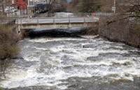
Friday showers led officials to close off a stretch of state Highway 5 between Fonda and Palatine after the road flooded. The curvy road was open again by Saturday.
While now passable, the storm did leave lasting damage on the shoulder of the route, which state highway crews are expected to work on throughout the week.
“Please stay alert and slow down when traveling through work zones,“ said state Department of Transportation regional spokesperson Heather Tehan.
In Columbia County, some portions of the Roeliff Jansen Kill were spotted by a Daily Gazette reporter on Saturday brimming the surface near roadways in Ancram. Earlier in the spring, the Claverack Creek flooded a field.
Columbia County Sheriff Don Krapf said that there hasn’t been any significant damage. Emergency crews have responded to pump out several basements in recent weeks.
“It seems like the ground is so saturated, that there is just no place else to go,” Krapf said. “This time of year, it is somewhat normal, but a little bit higher than we’re used to seeing.”
Images: High water around Capital Region (9 photos)

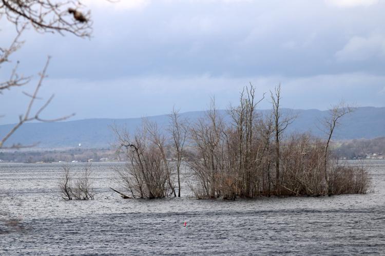
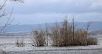
Waves strike the shore of Great Sacandaga Lake at the Broadalbin Boat Launch in Broadalbin Sunday as high water has risen covering the concrete boat ramp and causing nearby islands and outlets to disappear.

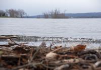
Waves strike the shore of Great Sacandaga Lake at the Broadalbin Boat Launch in Broadalbin, Sunday, April 14, 2024 as high water has risen covering the concrete boat ramp and causing nearby islands and outlets to disappear.

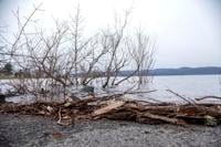
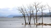
A view from the top of the Broadalbin Boat Launch in Broadalbin, Sunday, April 14, 2024 with Great Sacandaga Water rising, covering the concrete boat ramp and causing nearby islands and outlets to disappear.

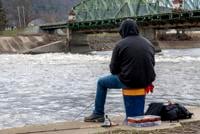
Matt Haberek of Scotia fishes from the lower side of Erie Canal Lock 9 in Rotterdam Junction as water rushes past on the Mohawk River Sunday, April 14, 2024 after steady rain has caused water levels to rise throughout the Capital Region.

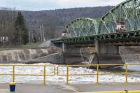
Water rushes through Erie Canal Lock 9 in Rotterdam Junction on the Mohawk River Sunday, April 14, 2024 after steady rain has caused water levels to rise throughout the Capital Region.

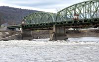
Water rushes through Erie Canal Lock 9 in Rotterdam Junction on the Mohawk River Sunday, April 14, 2024 after steady rain has caused water levels to rise throughout the Capital Region.

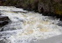
Water rushes over Kirk Douglas Park Falls on Guy Park Avenue Extension in Amsterdam Sunday, April 14, 2024 after steady rain has caused water levels to rise throughout the Capital Region.

Water rushes over Kirk Douglas Park Falls on Guy Park Avenue Extension in Amsterdam Sunday, April 14, 2024 after steady rain has caused water levels to rise throughout the Capital Region.

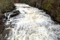
Water rushes past Kirk Douglas Park Falls on Guy Park Avenue Extension in Amsterdam Sunday, April 14, 2024 towards the Mohawk River after steady rain has caused water levels to rise throughout the Capital Region.